
![]()

California Real Time Network (CRTN)
News 3/13/2024: Updated Station Excel Worksheet; Removed stations no longer in operation; Added DWR stations Q189, Q204, Q208) and Verquin station GZKA; Removed BARD stations that were moved to new locations - they do not have 2017.5 coordinates yet.
[Caution: added comment on a subset of (CTSRN) stations that have 2019.55 coordinates rather than Epoch 2017.5 - see column T in spreadsheet]
Description
The California Real Time Network (CRTN) is a multipurpose statewide GNSS network that utilizes the existing geophysical and geodetic infrastructure for two primary purposes: (1) research into earthquake, tsunami and extreme weather early warning and rapid response, and (2) to provide a public utility in support of real-time kinematic and dynamic positioning. CRTN is managed through the California Spatial Reference Center (CSRC) and overseen by the CRTN Consortium.
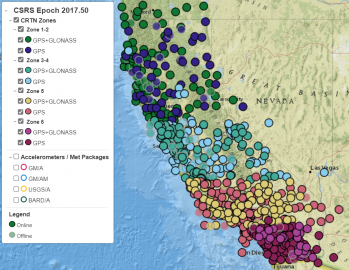
CRTN Status Map - updated every 5 minutes
Request Free CRTN Account
CRTN offers one free RTCM data stream per organization for single-base positioning with respect to the California Spatial Reference System (CSRS). Users must register with the CSRC to obtain access. To register, click here. Multiple data streams are available to Contributing and Consortium members. For more information, please click here or contact Maria Turingan (maria@ucsd.edu).
Support CRTN: Give to CRTN. Donations to support CRTN and to keep it operational are needed and appreciated. At the giving website, please confirm that it states "For California Real Time Network Support" and please do not include special instructions. If you have instructions or comments, please email your comments to Maria (maria@ucsd.edu).
Connecting to CRTN: Utilizing CRTN for RTK positioning requires a survey grade dual-frequency GNSS receiver with NTRIP protocol and a real-time connection (e.g., direct Internet, cell modem). The user makes a connection via NTRIP, enters their CRTN username and password and receives a list of the active CGPS base stations. The user then selects the desired CGPS base station and receives the RTCM data stream for RTK surveying. RTCM 3.0 data at a rate of one sample per second (1 Hz) are available in NTRIP protocol from GNSS stations with a latency of less than one second. Details here
Data Sources: CRTN is a clearinghouse of high-rate real-time GNSS data obtained from multiple servers, at EarthScope (NOTA), UC Berkeley/USGS Menlo Park (BARD), USGS Pasadena (SCIGN), Caltrans (CVSRN), Orange County Public Works (OCRTN), and SOPAC (SCIGN). SOPAC and some NOTA stations in southern California are supported by a dedicated communications network HPWREN.
Reference Frame (datum): The RTCM streams contain CSRS Epoch 2017.50 (NAD83) coordinates and station metadata (antenna and receiver models, antenna height and reference point). CRTN fulfills the requirements of the California Public Resources Codes 8856(c)(e), 8857(c), and 8858(b) for GPS-derived geodetic coordinates and orthometric heights.
Metrics

Historical Alerts
Problem solved (10/18/2021): David Harris (Aspen Survey) reported a problem downloading Ntrip sourcetable for CRTN subnetwork (132.239.152.175:2103). Here is his response: "I was able to communicate with my hardware / software providers. After a lot of trial and error, it has been discovered that the sim card in my device is bad. I was able to log on to the CRTN using my iphone hot spot. I will be contacting the Sim card provider to get a replacement."
News (10/16/2020): Cost savings at Los Angeles County Public Works from CRTN usage (Steve M. Hennessee, Principal Engineer).
Update (9/23/2020): This problem has been resolved. Users were reporting intermittent delays (up to 30 seconds) in receiving RTCM data streams from CRTN.
News (6/29/2020): We've added 89 stations in southern California - 65 in Zone 5 and 24 stations in Zone 6. These data are from the U.S. Geological Survey (USGS) with the data coming through the UNAVCO NOTA server. Thanks to USGS and UNAVCO for facilitating access to these data.
News (10/27/2019): With the increase in the number of CRTN stations, CRTN is now divided into 4 subnetworks according to California Coordinate System (CCS83) zones, accessed through two IPs and 4 ports (2 ports per IP):
Southern California, Zone 6: 132.239.154.80:2103
Southern California, Zone 5: 132.239.154.80:2104
Northern California, Zones 3-4: 132.239.152.175:2103
Northern California, Zones 1-2: 132.239.152.175:2104
Note: The Google Map (to the right) has not yet been updated to reflect these changes.
Historical Notices
News 2/22/2023: Added 12 Caltrans Spatial Reference Network (CTSRN) stations throughout the state - Courtesy of Eric Adney & Bryan Banister, Caltrans District 6
Feedback from User 1/27/2023 (from Jason Burak): "Yesterday Lee and I did some troubleshooting for the CRTN connection to our DJI Mavic 3 Enterprise RTK drone. The issue was that I had my cell phone connected to the Verizon MIFI WIFI hotspot. Once I turned off the WIFI on my phone the drone connection worked. I was able to repeat the connection issue by reconnecting my cell phone to the hotspot. I hope this helps other people that might be encountering the same connectivity issues."
News 12/20/2022 10:34:24 UTC: Minimal effect on coordinates for M6.4 Ferndale earthquake, N26.43123,W140.09766; 17.9W km depth. The earthquake caused a minimal shift in coordinates - maximum horizontal offset of 0.066 ft (2 cm) at station P161, less than 1 cm at other stations in the epicentral region. No detectable vertical motions.
News 7/10/2022: New CRTN Status Map
News (1/24/2022): We were forced to demobilize the CRTN station at Sonora High School (SNHS), part of the Orange County Real Time Network (OCRTN). This occurred on 12/22/2021. The station had been down since 2/10/2021. SNHS was installed on 3/24/1999 as part of the SCIGN project, ending a 22-year run.
News (10/21/2021): CRTN has added seven Caltrans stations in Zones 3-4. 30 stations have been upgraded to GNSS capability (GPS+GLONASS) for a total of 431 stations out of 707.
News (9/17/2019): Added upgraded NOTA/PBO real-time stations bringing the total number of CRTN stations to 584, with 193 GNSS stations. This fills the gap in the Los Angeles area (see CRTN maps). We plan to include the 91 USGS SCIGN stations when data become available in RTCM3 format.
News (7/18/2019): The flow of data from the Orange County Real Time Network (OCRTN) has been transitioned from Orange County Public Works (OCPW) in Santa Ana to SOPAC/CSRC through UCSD's HPWREN network. The nine stations of the OCRTN were established in the period 1994-2003 under the leadership of OCPW's John Canas and Art Andrew, in collaboration with the PGGA and SCIGN projects. Kudos to Art and Glen Offield for making this happen.
Alert (10/15/2019): With the increase in the number of CRTN stations, users have reported the inability to download the NTRIP source tables with several data controllers (Trimble, KQ Geo K8). We are working to resolve this problem. Please contact us if you encounter this problem (mrturingan@ucsd.edu).
Alert (4/25/2019): The GPS week number rollover on April 6 caused inaccurate positions for those using CRTN data streams with some versions of Trimble R8 receivers. Our users at the County of San Diego indicate that an upgrade to R8-3 firmware 5.40 solved the problem. Please contact your Trimble dealer for more information.
Alert (3/26/2019): It was discovered that the northern California CRTN server (132.239.152.175) was transmitting incorrect coordinates in the RTCM3 messages. This started on January 16th when we moved the server to another workstation. The problem was resolved in the late afternoon of March 26th. Anyone who relied on the CRTN coordinates over this time period will need to revisit their rover coordinates. Please contact us if you believe your surveys may have been affected by the erroneous coordinates. Note that the southern California server was not affected. Thanks to Jim Frame and Art Andrew for discovering the problem. We are sorry for the inconvenience.
Alert (10/12/2018): We have not been receiving real-time data from the USGS SCIGN stations in southern California for the last month. This causes a significant gap in coverage in the greater Los Angeles area. We do not know when the USGS service will be restored.
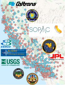
CRTN provides a clearinghouse of real-time GNSS data in California and the borders of neighboring states. This figure shows the multiple agencies that contribute RTCM3 data to support RTK users.
Click on graphic to access CRTN Status Map - updated every 5 minutes