|
|
 
King County and the City of Seattle Launch Summer Heat Mapping Campaign
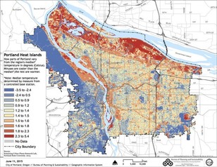
King County and the City of Seattle are partnering with Portland State University researchers to conduct a one-day heat mapping campaign this summer to collect real-time, ground-level temperature data to find the hottest places in our region. Data collected by volunteers will be used to develop a detailed temperature map of all of King County (see image for Portland example).
Urban areas are especially prone to high temperatures due to a combination of hard surfaces (buildings, roads), limited vegetation, and heat-producing factors like car use and industrial activity. This problem, known as the urban heat island effect, can create issues for human health, public and private infrastructure, and overall quality of life. Understanding how temperatures vary based on land cover can inform how we adapt to climate change and rising summer temperatures in our communities.
As we start to see warmer temperatures, be sure to check out the Stay Safe in the Heat comic developed by Public Health - Seattle/King County. The comic was developed to provide guidance for preventing heat illnesses during hot weather, especially for people who are at higher risk. This comic is available in twelve languages. Read and download them here.
|
Share Your Input on King County's Climate Action Toolkit
King County is partnering with the King County Cities Climate Collaboration (K4C) to develop a Climate Action Toolkit for use by cities to accelerate our carbon emission reductions at the community scale and within local government operations. This toolkit will reflect the framework of the updated K4C Joint Commitments and King County’s 2020 Strategic Climate Action Plan.
The toolkit will provide guidance on a mix of actionable and practical strategies that fit cities with different types of land use, population, energy supply, and transportation patterns. The recommendations of the toolkit will help guide cities that are just getting started in climate planning, as well as those seeking to move faster and farther.
Your voice is important! Please share your input to inform the priorities and actions of the Toolkit to reflect the values of King County communities.
Share your input today: https://publicinput.com/climateactiontoolkit
|
|
|
|
|
Winner Announced for KUOW's Biggest Carbon Loser Series

Prior to the COVID-19 outbreak, Seattle's NPR public radio station KUOW produced a reality-radio reduce-your-carbon-footprint competition called the Biggest Carbon Loser. The final results have been announced and you can see how much each contestant was able to reduce their carbon footprint! Although the contest ran from January through February 2020, KUOW notes that circumstances have changed in the current time, but that action on climate change is still just as urgent.
KUOW’s Biggest Carbon Loser series aimed to see how deeply three Seattle-area residents could cut their carbon footprints -- from travel, food, energy, and more -- while navigating their daily lives. Whoever cut their carbon footprint the most won the coveted title of Biggest Carbon Loser. Each contestant had a "carbon coach" and King County employee, Tom Watson, was coaching one of them! Tom manages the EcoConsumer program in the Solid Waste Division of the Department of Natural Resources and Parks.
You can listen to past episodes of KUOW's 5-minute segments about how these contestants have worked to reduce their individual carbon footprints and the challenges and limitations they faced.
|
You can learn more about County climate actions and strategies on our website. Find information on our Strategic Climate Action Plan (SCAP), Partnerships and Collaborations, and Initiatives and Programs. Learn more about climate change, its impacts in King County, and what you can do.
|
|