

Carkeek Park is located in northwest Seattle, between 3rd Ave NW and Puget Sound. The park includes all of Piper's Creek (sometimes written without the apostrophe) plus the adjoining side hills and some side streams, plus a beach area. Park trails can be accessed from several points, and there is an access road that leads to a parking area near the beach. Park entrance is free, and official hours are daily, 6 a.m. to 10 p.m.
The hike described here includes the entire length of Piper's Creek, plus a number of trails on the north and south ridges above the creek. For a shorter or easier hike, a glance at the trails map will suggest other possibilities.
Begin your hike at the Eddie McAbee Entrance on NW 100th Place, near 6th Ave NW. There's a signboard at the trailhead with a park map and often, paper copies of a trail map available for the taking. Trail maps also can be downloaded. Additional trailheads are mentioned below and, since this is a loop hike, other starting points could be considered. For additional details, see the Driving Directions.
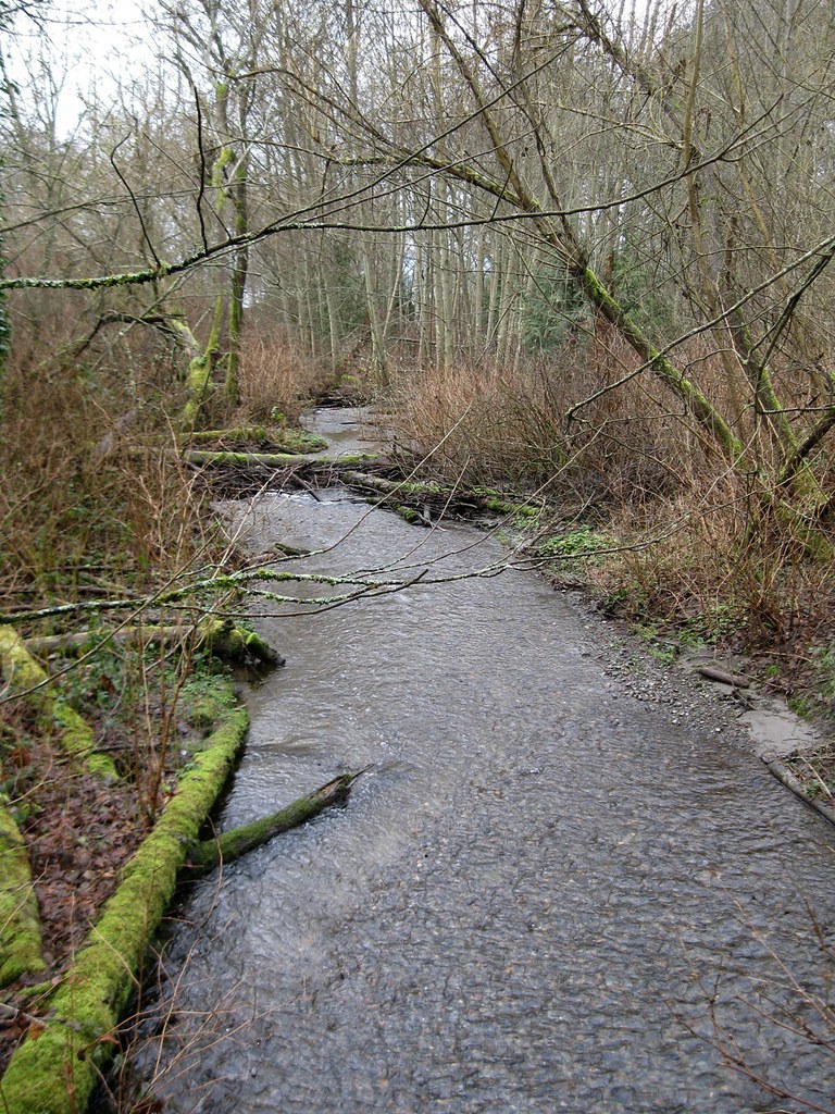
The Piper's Creek Trail begins with a quick descent on four short switchbacks to reach the headwaters of Piper's Creek. The creek at first is not much more than a trickle. But, as you follow the trail downstream the creek becomes more substantial in response to inputs from seeps and from additional trickles and rivulets, some arriving via side canyons, others via culverts from the surrounding highlands.
In a quarter-mile your trail is joined on the right by the Viewlands Trail, another option for reaching Piper's Creek. You can find trailheads for the Viewlands Trail north and south of the Viewlands Elementary School. The two branches come together behind the school, in a blackberry patch, before descending to Piper's Creek.
As you continue down the Piper's Creek Trail, the steep-sided canyon sports many tall trees, both deciduous and coniferous, and during major storms blowdowns are common. The winter of 2014-15 seems to have been a difficult one for the tall trees, and many new blowdowns are evident.
You will pass Piper's Orchard, now considerably restored. Just beyond the orchard, your trail crosses a small creek that once provided irrigation water for the orchard and gardens. In February, snowdrops (galanthus) bloom on the slope between the creek and the orchard. They are not native, but are long-established in the area. They are one of the earliest flowers to bloom in the park, along with the native Indian plum.
As you proceed down Piper's Creek Trail, a brown building begins to loom up downstream. The unlovely edifice is a Metro sewage pumping station that gathers and sends piped effluent on toward the main treatment facility at West Point. The pumping station seems to have no discernible impact on Piper's Creek.
Before reaching the station, note a trail junction on the right. The trails map identifies it as the aptly-named Fern Glen Trail. Turn here and hike the short trail up the side canyon, gaining 100 feet, and coming to the park access road. Cross the road and enter the parking area for the Environmental Learning Center. As of 2015, the Center remains closed due to city funding problems. The parking area offers another access point for park trails.
Cross the meadow, past picnic tables, to the west side and note the Education Center Trail coming down the hill from the right. That short trail gains a mere 40 feet to reach NW 116th street, and another possible trailhead for park access. It's worth taking the five minute side trip up that trail, and back, for the views down on the canyons of Mohlendorph Creek and Venema Creek.
After the side trip, find the ongoing trail at the southwest corner of the meadow and descend it back to the road. Follow the road west just a few feet, crossing over Mohlendorph Creek, and find the 12th Avenue Hillclimb Trail just past a Speed Bump sign. Either take this trail or, for a less ambitious hike, cross the road and rejoin the Piper's Creek Trail continuing west along the creek.
In late October and early November you might prefer the creekside option anyway, because in many years Piper's Creek has a significant fall salmon run. Current efforts to restore the run begin at area schools, where fertilized eggs obtained from hatcheries actually hatch. Tiny salmon fry are relocated to a holding tank at the confluence of Mohlendorph and Venema Creeks, and the fry are imprinted with the "flavor" of water from Venema Creek. They are released and go to sea for a few years, and then survivors return to Piper's Creek to spawn. A few even seek to fight their way up tiny Mohlendorph Creek to the site of the holding tank.
Unless you are returning to the Piper's Creek Trail, take the 12th Avenue Hillclimb a short way uphill and come to a signed junction. The right fork continues up to 12th Ave NW, another access point for park trails. The left fork, your ongoing route, is the North Traverse. Here, and elsewhere in the park, be alert for the loud tapping of pileated woodpeckers that sometimes are seen along park trails.
The North Traverse is joined by a short trail coming up from a parking area, and soon it meets the Grand Fir Trail, an unmistakable trail heading uphill to the right. You might wonder about a much fainter path a few feet before you reach the Grand Fir Trail. It formerly provided access to a trailhead on NW 116th St. But the landowner at the upper end has posted that former trailhead No Trespassing. Until the legal situation is clarified it will be better to avoid that faint trail. Instead, continue a few steps farther on the North Traverse and take a sharp right turn onto the Grand Fir Trail.
Follow the Grand Fir Trail uphill and soon reach another trail junction at Signpost Number 2. The trail arriving from the right comes from an official park trailhead on NW 117th St. Continue on the trail that heads left, cross a small stream, and come to a junction with the North Meadow Hillclimb. Turn right, and head uphill, passing a large granite boulder (a glacial erratic) along the way, and join the North Bluff Trail. Turn right and, in a couple of minutes, reach the small North Meadow. You have come up about 200 feet from Piper's Creek.
The meadow is bordered by back yards and offers no street access, so please stay on park land. During the winter, when leaves are down, there are views out to Puget Sound and the Olympics, but these are obscured when trees leaf out in the spring. Note a tall fir just down slope from the meadow. Sometimes a bald eagle, or even a pair of eagles, is seen perched at the top.
Descend the North Bluff Trail all the way down to the picnic area, dropping about 240 feet. Along the way there are brief views out to the Sound and down to the railroad tracks. When you reach the picnic area it may be well attended. Often, school events are held there. There are unobstructed views across the Sound to the Olympics, and a display board helps to identify Olympic peaks.
A bridge crosses over the railroad tracks to provide beach access. Feel free to explore the beach, but please stay off the tracks. Trains can appear suddenly, sometimes from both directions at once, and there have been fatalities here.
Just beyond a signboard next to the bridge, take the stairs down toward the fence and continue on, passing a junction with the Wetlands Trail (a western extension of the Piper's Creek Trail.) Cross over the lower end of Piper's Creek as it enters a tunnel under the tracks. Come to a grassy field, and follow the fence to reach the South Bluff Trail.
Climb steeply up the trail, gaining 180 feet, to reach the tiny South Meadow with a bench and (leaves permitting) more views out to the sound. Then head east on the South Ridge Trail. In just a few feet, at Signpost Number 3, a trail leaves the park headed south. It leads to Mary Ave NW, another possible park access point.
Stay on the South Ridge Trail. In less than a half-mile, come to Signpost Number 7, where a trail arrives from NW Norcross Way, yet another park access point. Continue on the South Ridge Trail, cross two small streams on rustic bridges, and descend, dropping 140 feet, back down to Piper's Creek at Signpost Number 8. Turn right here, cross Piper's Creek on a new metal-decked bridge (a replacement for a wooden bridged severely damaged by blowdowns) and return to your trailhead via the Piper's Creek Trail, gaining 220 feet on the way.
History
The Piper family tended gardens and planted fruit trees in a logged-over area near the creek beginning in the 1880s. Their produce was hauled by wagon to city markets, then some distance away. Andrew Piper was a baker, candy maker and artist, and he was elected to the Seattle City Council as a Socialist. His wife Minna was the principal gardener and orchardist. Daughter Tillie, a Seattle school teacher, lived in a cabin at the site and was an early visitor to the Paradise area of Mount Rainier, then (1890) reachable only by horse.
Land for the park was acquired by the city in 1927, using funds donated by the Carkeek family. The Pipers' former orchard was long-forgotten and lay hidden by brambles for many years. It was rediscovered in 1981, and today the non-profit Friends of Pipers Orchard works to restore it. You might check the Historical Posts link at their website for more comments about life here in the early days of Seattle.
 Trailhead


